Flood Warnings ,..Severe thunderstorms and heavy rain affecting Sydney Newcastle Wollongong
Severe thunderstorms and heavy rain are affecting Sydney Newcastle Wollongong or surrounding areas. Whilst the immediate threat of severe thunderstorms has passed, the situation will continue to be monitored and further warnings will be issued if necessary.
A broader Severe Weather Warning for HEAVY RAINFALL and DAMAGING WINDS is still current.
Sydney (Observatory Hill) recorded 57.2mm in 60 minutes to 3:35am.
The State Emergency Service advises that people should:
* Keep clear of fallen power lines.
* Keep clear of creeks and storm drains.
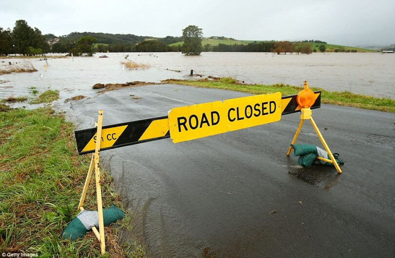
* Don’t walk, ride your bike or drive through flood water.
* For emergency help in floods and storms, ring the SES (NSW and ACT) on 132 500.
Warnings are also available through TV and Radio broadcasts, the Bureau’s website at www.bom.gov.au or call 1300 659 210. The Bureau and State Emergency Service would appreciate warnings being broadcast regularly.
The NSW SES is advising people in the following areas to STAY INDOORS due to damaging winds, and heavy to locally intense rainfall:
- Gosford
- Sydney
- Wollongong
- Nowra
- Batemans Bay
- Goulburn
You should monitor the situation as it is constantly changing.
What are we expecting?
The Bureau of Meteorology advises HEAVY RAINFALL which may lead to FLASH FLOODING is forecast for the southern parts of the Hunter to the Sydney Metropolitan, Illawarra, and Central Tablelands districts developing from the late morning, then shifting south to the remaining districts overnight into Saturday morning while easing from the north. Six-hourly rainfall totals between 50 to 90 mm are likely, reaching up to 130 mm over the Illawarra escarpment. 24 hour totals of 70-120 mm are also likely, reaching up to 150 mm over the Blue Mountains and Illawarra escarpment.
Within the broad heavy rainfall area, locally INTENSE RAINFALL which may lead to DANGEROUS AND LIFE-THREATENING FLASH FLOODING is possible between the Blue Mountains and Narooma from this evening into Saturday morning, with localised six-hourly rainfall totals between 90 to 150 mm possible, reaching up to 220 mm over the Illawarra escarpment. Localised 24-hourly rainfall totals between 120 and 200 mm are possible, and may reach up to 300 mm over the Illawarra escarpment. A separate Severe Thunderstorm Warning will be issued if very dangerous thunderstorms with intense rainfall are detected.
DAMAGING EASTERLY WINDS, averaging 60 to 70 km/h with peak gusts of around 90 km/h are possible from this evening along the coastal strip south of and including the Sydney metro area, as well as adjacent elevated areas, particularly above 500m.
This event may change quickly. We will monitor the situation and update our warnings if the situation changes.
What you need to do:
- Move or stay indoors clear of windows, bringing children and pets with you.
- If you must travel, consider the consequences of road conditions and closures and make alternate arrangements for work, children, and travel.
- Use stairs instead of lifts in severe weather. You may become trapped if the power goes out.
- If your roof or balcony is struck by a fallen tree/branch or