
Tropical Cyclone Alfred-Warnings-South Queensland and North NSW brace as Cyclone Alfred threatens Queensland’s Southern Coast
For the first time in five decades, Queensland’s capital could face the impact of a tropical cyclone, with Cyclone Alfred forecast to make landfall on Mar. 6.
Meteorologists predict the system will reach the south-east corner of the state as a category one, and will potentially stretch over 150 kilometres from the Sunshine Coast to the state capital Brisbane, and to the Gold Coast/New South Wales border.
The last event to hit the heavily populated South-east Queensland region was Cyclone Zoe in 1974.
Wind speeds near the cyclone’s centre have reached 95 kilometres per hour, with gusts of up to 130 kilometres. The system is already triggering massive waves up to 15 metres high, causing significant coastal erosion from Fraser Island to the Gold Coast.

A screenshot taken from the Bureau of Meteorology website shows a satellite image of Tropical Cyclone Alfred approaching the Queensland coast, Sunday, March 2, 2025. Bureau of Metereology Image
*Update 18.00 hours Monday 03 March,2025
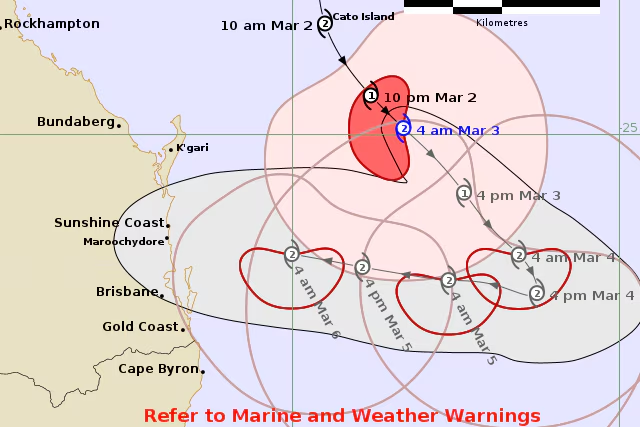
South East Queensland and North NSW residents are watching with growing concern as Tropical Cyclone Alfred barrels towards the south-east Queensland coast, poised to deliver destructive winds and life-threatening flooding later this week.1 The Bureau of Meteorology (BOM) has issued a stark warning, placing a vast swathe of the region on high alert, including popular tourist destinations like the Gold Coast and Sunshine Coast.
Alfred, currently tracking towards the coast, is forecast to make landfall as a category two cyclone, potentially between the bustling Gold Coast and the southern reaches of the Wide Bay region. This would mark a significant and rare event, being the first cyclone to impact Queensland’s southern coast in half a century.4
The system is expected to steadily approach the coastline from Tuesday onwards, with landfall predicted for Thursday or Friday.5 Residents are bracing for a barrage of severe weather, including:
- Destructive Winds: Strong gusts capable of causing significant property damage and power outages.
- Life-Threatening Flooding: Large rainfall totals are expected, posing a serious risk of flash flooding and riverine flooding.6
- Coastal Erosion: Powerful waves and storm surge are anticipated, leading to significant coastal erosion.7
A flood watch has been issued for northern New South Wales and south-east Queensland, highlighting the widespread threat.8 The BOM’s current watch zone encompasses a large area, stretching from Sandy Cape to Grafton, and including major cities and towns such as Brisbane, the Gold Coast, the Sunshine Coast, and Byron Bay.9
“People living within those areas should consider what action they will need to take if the cyclone threat increases,” a BOM spokesperson stated. “It is crucial to stay informed and prepared.”
Sydney residents with family and friends in the affected areas are urged to maintain contact and ensure they are aware of the latest warnings and safety advice. As Alfred continues its approach, the Sydney Times will provide ongoing updates on the developing situation.
Alfred caused no damage. The highest reported wind was 83 km/h at 0600 UTC 5 March estimated by a ship 330 km from the centre.
Australian Bureau of Meteorology
Tropical Cyclone Warning Centre

TROPICAL CYCLONE INFORMATION BULLETIN
Issued at 4:52 am EST on Monday 3 March 2025

At 4 am AEST Monday, Tropical Cyclone Alfred (Category 2) with central pressure
984 hPa was located over the Coral Sea near latitude 24.9 south longitude 156.7
east, which is about 465 km northeast of Brisbane and 410 km east northeast of
Maroochydore.

Tropical Cyclone Alfred has strengthened to category 2. It will continue its
current southeastwards motion, further away from the Queensland coast, during
Monday. Alfred is then expected to slow down and turn westward from Tuesday,
moving towards the southern Queensland coast.

Severe coastal hazards are likely for southern Queensland and northern New
South Wales coasts. A large and powerful to potentially damaging easterly swell
as well as abnormally high tides are occurring about exposed southern
Queensland beaches, and are forecast to extend to northern New South Wales
coast from Monday.

Heavy to locally intense rainfall is forecast for southeast Queensland and
northeastern New South Wales from Wednesday as Alfred approaches the coast.
Flood Watches have been issued for these areas.

Refer to associated warnings for Queensland and New South Wales at
http://www.bom.gov.au/australia/warnings .

The next Information Bulletin will be issued by 11:00 am AEST Monday 03 March.