
Heatwave Warning For Sydney and New South Wales
- Summary

- Max 40
- Afternoon cool change. Possible storm.
- Possible rainfall: 0 to 1 mm
- Chance of any rain: 40%

Sydney area
Sunny morning. Medium chance of showers during the afternoon and evening. The chance of a thunderstorm during the afternoon and evening, possibly severe. Winds north to northwesterly 20 to 30 km/h shifting cooler, gusty southerly 30 to 50 km/h in the late afternoon, and reaching 50 to 60 km/h about the coastal fringe.
Fire Danger – High
Sun protection recommended from 8:50 am to 5:10 pm, UV Index predicted to reach 12 [Extreme]
Heatwave Warning For New South Wales
Issued at 02:40pm EDT on Monday 27 January 2025
Valid for Monday 27 January 2025 to Thursday 30 January 2025
Severe Heatwave Warning for: Mid North Coast, Hunter, Northern Tablelands, Metropolitan, North West Slopes & Plains, Central West Slopes & Plains, South West Slopes and Upper Western Districts
Cancelled Heatwave Warning for: Central Tablelands District
Heatwave Situation for 3 days starting Saturday 25th January 2025

Heatwave Situation for 3 days starting Sunday 26th January 2025

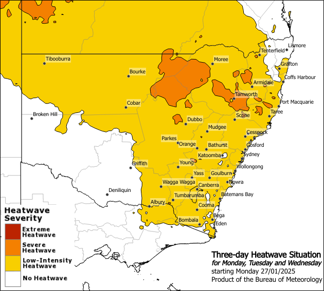
Heatwave Situation for 3 days starting Monday 27th January 2025

Heatwave Situation for 3 days starting Tuesday 28th January 2025

Safety Advice
- Severe heatwaves can be dangerous for many people, especially older people, babies, children, pregnant and breastfeeding women, people with medical conditions and people who are unwell.
- Seek a place to keep cool, such as your home, a library, community centre or shopping centre.
- Close your windows and draw blinds, curtains or awnings early in the day to keep the heat out of your home.
- If available, use fans or air-conditioners to keep cool.
For information on staying safe during a heatwave go to the NSW Department of Health web page.
Weather Situation
Maximum temperatures generally in the high thirties to low forties and overnight minimum temperatures in the high teens to mid twenties. A south to southwesterly wind changes will bring milder temperatures to the southern parts of NSW from Tuesday, reducing the maximum temperature to mid twenties to mid thirties, with overnight minimum temperature in low to mid teens from Wednesday. Severe heatwave conditions are developing across central and northern New South Wales and will persist in the next couple days, before easing from the middle of the week.
Locations likely to be impacted include Sydney metropolitan, Bourke, Camden, Cobar, Dubbo, Hornsby, Liverpool, Penrith, Richmond, Taree and Tamworth.
The next heatwave warning will be issued by 3:00pm EDT on Tuesday 28 January 2025