
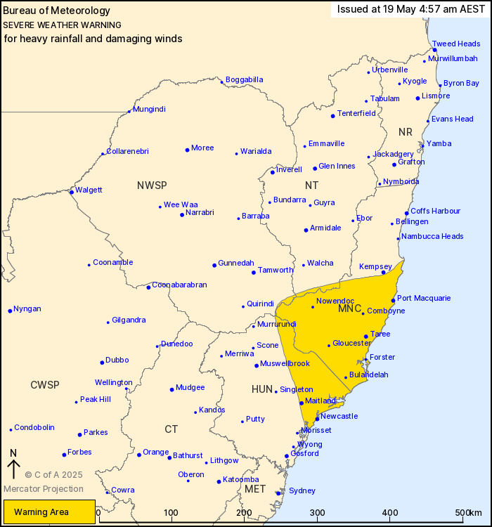
Severe Weather Warning for HEAVY RAINFALL and DAMAGING WINDS
For people in parts of Mid North Coast, Hunter, North West Slopes and Plains and Northern Tablelands Forecast Districts.
Issued at 4:57 am Monday, 19 May 2025.
*Heavy rainfall and damaging winds to continue about the northern Hunter and southern Mid North Coast.
Marine Wind Warning Summary-NSW Coast
Updated Marine Wind Warning Summary for New South Wales
Issued at 4:10 am EST on Monday 19 May 2025
for the period until midnight EST Tuesday 20 May 2025.
Wind Warnings for Monday 19 May
Gale Warning for the following areas:
Macquarie Coast, Hunter Coast and Sydney Coast
Strong Wind Warning for the following areas:
Sydney Enclosed Waters, Byron Coast, Coffs Coast, Illawarra Coast and Batemans Coast
Wind Warnings for Tuesday 20 May
Gale Warning for the following areas:
Coffs Coast and Macquarie Coast
Strong Wind Warning for the following areas:
Sydney Enclosed Waters, Hunter Coast, Sydney Coast and Illawarra Coast
The next marine wind warning summary will be issued by 4:05 pm EST Monday.
Sydney Forecast
View the current warnings for New South Wales
Forecast issued at 4:45 am EST on Monday 19 May 2025.
Forecast for Monday 19 May
- Summary

- Max 19
- Showers.
- Possible rainfall: 5 to 25 mm
- Chance of any rain: 90%
Sydney area
Cloudy. Very high chance of showers, becoming less likely during the morning. The chance of a thunderstorm along the coastal fringe this morning. Winds southerly 25 to 35 km/h.
Large and powerful surf conditions are expected to be hazardous for coastal activities such as rock fishing, swimming and surfing.
Fire Danger – No Rating
Sun protection recommended from 11:20 am to 12:20 pm, UV Index predicted to reach 3 [Moderate]
Tuesday 20 May
- Summary
- Min 15
- Max 21
- Showers.
- Possible rainfall: 4 to 20 mm
- Chance of any rain: 80%
Sydney area
Cloudy. High chance of showers. Winds southeast to southwesterly 20 to 30 km/h becoming southeasterly 15 to 25 km/h in the morning then tending southerly 15 to 20 km/h in the evening.
Large and powerful surf conditions are expected to be hazardous for coastal activities such as rock fishing, swimming and surfing.
Sun protection recommended from 11:00 am to 12:30 pm, UV Index predicted to reach 3 [Moderate]
Wednesday 21 May
- Summary
- Min 15
- Max 21
- Showers.
- Possible rainfall: 7 to 35 mm
- Chance of any rain: 90%
Sydney area
Cloudy. High chance of showers. Winds south to southeasterly 15 to 20 km/h.
Sun protection recommended from 11:50 am to 12:50 pm, UV Index predicted to reach 3 [Moderate]
Thursday 22 May
- Summary
- Min 15
- Max 20
- Showers.
- Possible rainfall: 2 to 25 mm
- Chance of any rain: 90%
Sydney area
Cloudy. High chance of showers. Winds south to southeasterly 15 to 25 km/h.
Sun protection not recommended, UV Index predicted to reach 2 [Low]
Friday 23 May
- Summary
- Min 16
- Max 22
- Showers.
- Possible rainfall: 1 to 20 mm
- Chance of any rain: 80%
Sydney area
Cloudy. High chance of showers. The chance of a thunderstorm. Winds southeast to southwesterly 15 to 20 km/h tending easterly during the morning.
*For people in parts of Mid North Coast, Hunter, North West Slopes and Plains and Northern Tablelands Forecast Districts.
Weather Situation: A coastal trough is forecast to deepen and stall about the Mid North Coast and northern Hunter districts today, with persistent moderate to heavy rainfall expected in a moist onshore flow through to Wednesday.
Prolonged moderate rainfall with isolated areas of HEAVY RAINFALL which may lead to FLASH FLOODING is forecast for parts of the southern Mid North Coast, northern Hunter and adjacent parts of the North West Slopes & Plains and Northern Tablelands districts. The heaviest falls are expected to develop during today and continue through Tuesday, with further rainfall possible into Wednesday. Six-hourly rainfall totals between 50 and 80 mm are likely, with isolated rainfall totals of 120 mm possible. 24-hourly totals between 70 and 130 mm are likely, with isolated rainfall totals of 180 mm possible.
Strong southeasterly winds averaging 50 to 70 km/h, with DAMAGING WIND GUSTS of around 100 km/h are expected over the coastal areas of the Hunter and Mid North Coast, and elevated terrain further inland during today and into Tuesday Morning.
Flood watches are current for multiple catchments, and hazardous and damaging surf warnings are also current for parts of the state. For details, please refer to http://www.bom.gov.au/nsw/warnings/.
Locations which may be affected include Newcastle, Port Macquarie, Taree, Wingham, Nelson Bay, Dungog and Yarrowitch.
Norah Head has observed an average wind speed of 81 km/h and a wind gust of 105 km/h at 10:30pm Sunday.
Dorah Creek in Newcastle recorded 67mm in the 2 hours to 11:12pm Sunday.
The State Emergency Service advises that people should:
* Don’t drive, ride or walk through flood water.
* Keep clear of creeks and storm drains.
* If you are trapped by flash flooding, seek refuge in the highest available place and ring 000 if you need rescue.
* Be aware that run-off from rainfall in fire affected areas may behave differently and be more rapid. It may also contain debris such as ash, soil, trees and rocks.
* After bushfires, heavy rain and the loss of foliage can make the ground soft and heavy, leading to a greater chance of landslides.
* Move vehicles under cover or away from trees.
* Secure or put away loose items around your house, yard and balcony.
* Keep at least 8 metres away from fallen power lines or objects that may be energised, such as fences.
* Trees that have been damaged by fire are likely to be more unstable and more likely to fall.
* Report fallen power lines to either Ausgrid (131 388), Endeavour Energy (131 003), Essential Energy (132 080) or Evoenergy (131 093) as shown on your power bill.
* Stay vigilant and monitor conditions. Note that the landscape may have changed following bushfires.
* For emergency help in floods and storms, ring your local SES Unit on 132 500.